Shuyang Huang

Shuyang Huang is from Shanghai, China, and her name is pronounced Shoo-Young Huang in English. She attained a Bachelor of Science degree in Human Geography at East China Normal University. Her concentrations at GSAPP are Urban Analytics and Built Environment. In her leisure time, she has been playing cello for 14 years since ten, and was proudly titled as the Principal Cellist for her college orchestra.

Email: sh3685@columbia.edu

Cloudy Night: Activating Park Space by Illuminated Interactivity

Team

Nick Kunz: nhk2119@columbia.edu, 602-710-8608
Shiori Osakata: so2522@columbia.edu, 646-983-4947
Shuyang Huang: sh3685@columbia.edu, 347-415-4652

Video

https://youtu.be/UFdZAbp3dc4

Hero Image

Executive Summary

Cloudy Night is an interactive lighting and data collecting prototype. The device was developed to provide illuminated feedback loops in low light conditions throughout the city while collecting unidentifiable data on its participants. The intent of the project was to assess if interactive lighting could enhance public park engagement and safety. The first deployment occurred on May 4th, 2019 at Starlight Park in the Bronx, New York.

The stakeholders of the project were the Bronx River Alliance with special consideration given to the people and parks they serve. After a 3 hour deployment of the prototype in the afternoon and evening, the collected data was analyzed for quality, focusing on interpretability and inference. It was found that both directionality of human movement and the presence of children could be roughly approximated. The presence of children was used as a proxy for the perception of public safety, where it was assumed that mothers will not bring their children into environments that are perceived to be unsafe.

Although this was assumed, and a rigorous analysis was not conducted to assess the number of occurrences of each event, it was more important that this project demonstrated that capturing these areas of interest was possible. It was determined that the Cloudy Night prototype was a useful device for creating interactive illuminances, while assessing rough approximations of public park safety and human movement through both directionality and the presence of children.

Implementation

Implementation in the Starlight Park

Analysis

General Trends of Human Presence

Direction Plot (17:30 – 17:35)

Analysis of Children Presence (18:20 – 18:23)


Measuring the economic value of the park

Introduction 

Executive Summary

Successful cities and communities are usually equipped with sufficient provision of houses, retails and public spaces so that the needs of different groups of people can all be met. The value of these features create together is larger than their values as parts. Parks and green spaces are important parts of the living environment, which have a huge role in determining how welcoming and healthy a city is. Besides huge social and health benefits, parks and green space also create a massive financial impact. According to the 2015 City Park Facts Report, the total economic value generated in 2015 is one hundred and twenty-six billion more than the total governmental spending on parks. The project aims to measure the economic value of Starlight Park, a 13-acre park located in Bronx, NY. We intend to use PIR sensors and Wi-Fi sniffers to detect the person visits of three main types of park direct uses including general park uses, park facilities use and special uses. Each type of park direct uses is assigned a dollar value based on people’s “willingness to pay” for similar recreation experience in the private marketplace. By adding them together we can obtain the economic value of the park. Due to a bunch of limitations, data collected in this project is not enough to tell the story of Starlight Park. However, the methodology proves that there could be a relationship between the design of public space and its uses that we can rely on. The fact that we could not get the information we want gives us some frustrations. While in the meantime it shows how far we could go from data privacy and efficiency based on the fact that we still need to deal with data privacy issues and other legal procedures in such practice. This pilot is the first step for us to create a smart system for a park or other types of public space in the future. It also, in a meaningful way, leads to further investigations of how to deal with urban matters based on what we need.

Figure1. System infrastructure 

Hero Picture

Figure2. Interactive web map demonstrating the data visualization (Link:https://yichenouyang.carto.com/builder/29ecfe93-e65e-468d-9720-8d4a20c6a408/embed)

Figure3. PIR sensor and Wi-Fi sniffer 

Figure 4. Pilot in Starlight Park

Team Names, and mechanism for contact

  • Danting Luo <9173464774>;<dl3149@columbia.edu>
  • Yichen Ouyang <6466233632>; <yo2286@columbia.edu>


The Price is Right! Rapid Deployment for Analyzing Parking Resource Use

Ethan Hudgins: ejh2195@columbia.edu
Will Reis: war2120@columbia.edu

Project Description

This study will examine the practicality of reliance on sensors for rapid deployment and data collection of parking resource use for cities. This project is predicated on the idea that parking surveys require significant manpower for data collection, as well as significant time to produce the data on what parking spaces are used and how frequently. This project seeks to create a sensor that can be rapidly deployed across a wide urban landscape, and within a few hours identify where demand pricing or other parking management policies could be employed to rectify issues such as continuous circling, low turnover, or even too high of a price.


What data is being collected, and why.

The sensor being deployed is effectively a radar (radio waves); the sensor sends and receives these waves in a grid that can tell us where (and possibly what) is in the parking space. We are hoping to be able to reliably estimate if the spot is empty or if there is any sort of vehicle in the spot, including scooters. The data will inform us how often a parking spot is occupied, the rate of turnover. From this, we can acquire an occupancy rate, and we can make recommendations from the information. In the future, these could be rolled out for several days and accomplish a much more voluminous and reliable set of data, with much less manpower from the consultant side.


Harms to subject/public, if any.

There are no anticipated harms to the public. The only major concern we have is the possibility that this is a tripping hazard, and the public could get sued for deploying sensors on the side of curbs that could trip people. Additionally, we are concerned about the vandalism of these sensors. The data being collected has no identifying information to individuals, and cannot produce harm to the public in any conceivable way.

Cloudy Night: Activating Park Space by Illuminated Interactivity

Team

Shiori Osakata: so2522@columbia.edu, 646-983-4947

Shuyang Huang: sh3685@columbia.edu, 347-415-4652

Nick Kunz: nhk2119@columbia.edu, 602-710-8608
Brief Discription

“Regardless of park size, safety begins at the perimeter. An active edge, which will encourage use and create a perimeter of surveillance for the park,  can also increase park accessibility to user groups who may feel more vulnerable in the park interior and who are of lower mobility, such as women, children, older adults and people with disabilities.”  — Quote from Project for Public Space (https://www.pps.org/article/what-role-can-design-play-in-creating-safer-parks)

We will focus on sensing the presence of children in the park, as an indicator of safety. The main goal of our project is to understand perceived safety (reflected by children presence) and seek to enhance the experience in a park while simultaneously addressing the need for public safety and an empirical way to measure it.

We want to capture if illuminating areas in the park containing low light visibility with fun, interactive, and playful feedback loops can enhance park engagement and public safety. The audience of the project will be the NYC parks, who are in charge of the design and maintenance of the parks.

Research questions

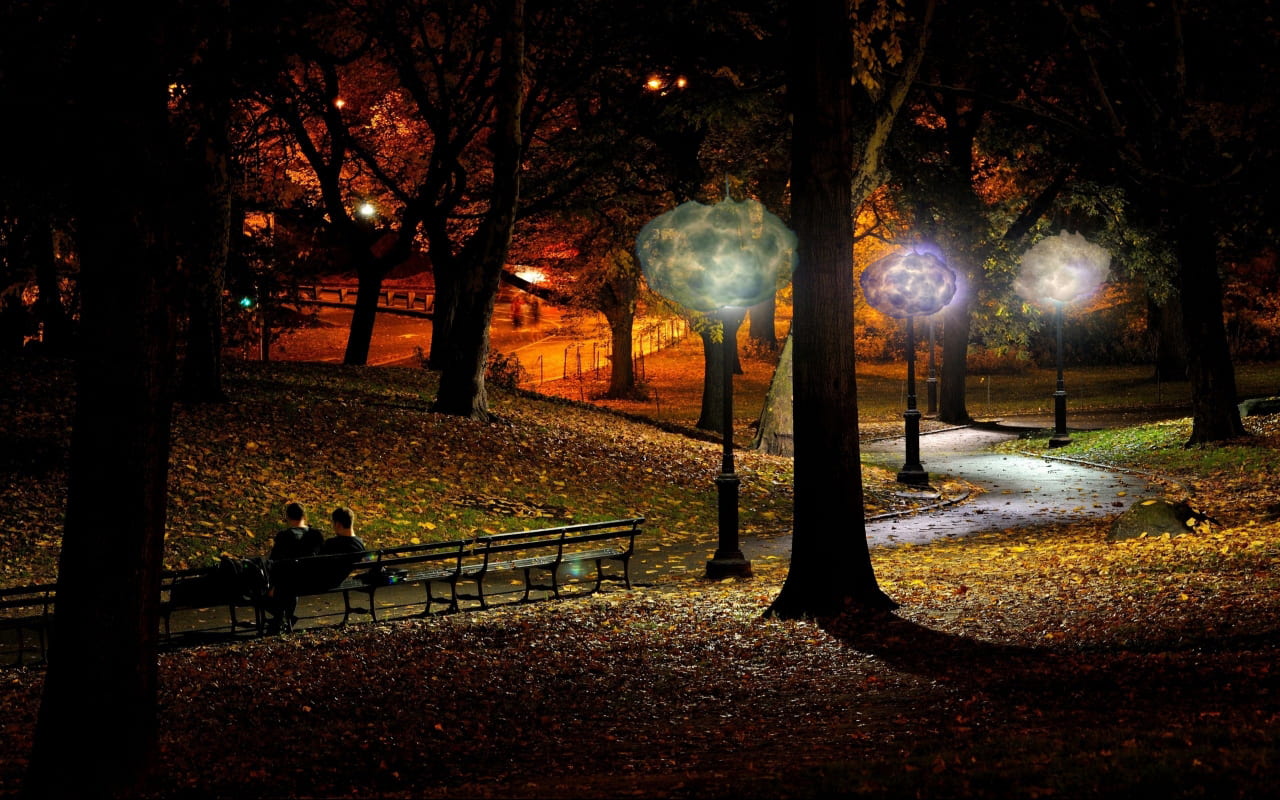
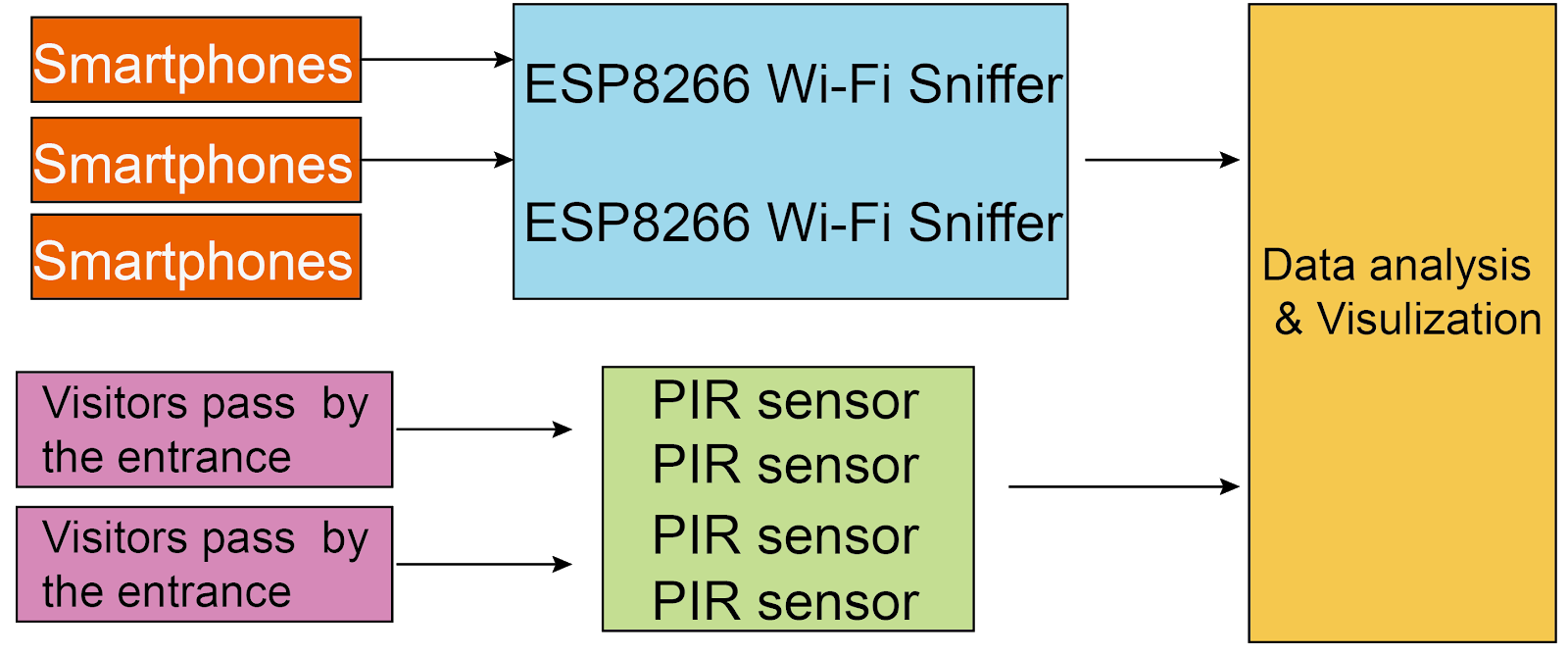
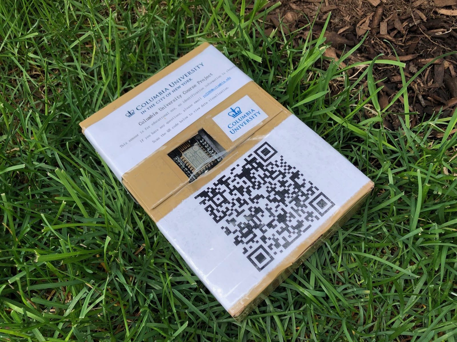
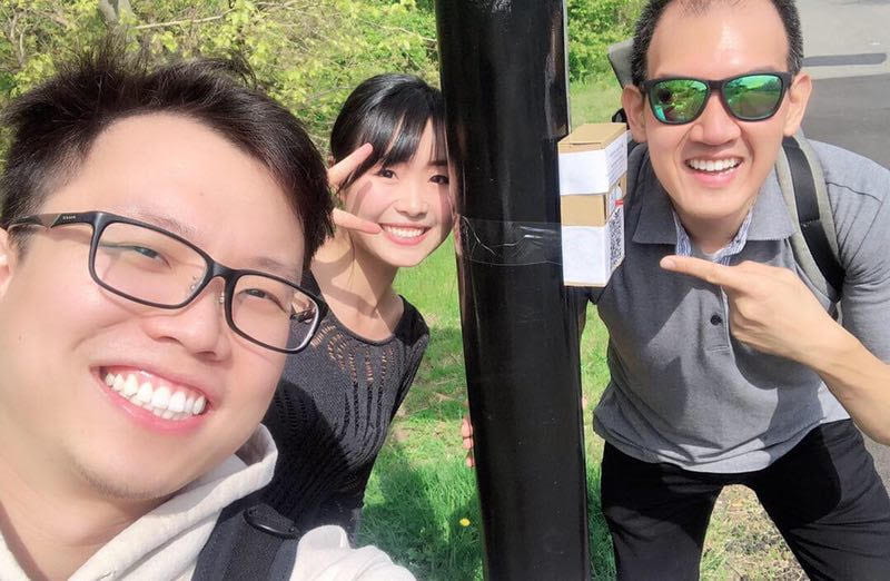
Sensors embedded in an interactive device called Cloudy Night will be applied under the bridge in the north side of starlight park, which has potentially low visual access but an important traffic road in that area. By sensing the presence of people around the Cloudy Night, we can answer the research question that: 1) does illuminating low light visibility in park spaces with interactive devices make people feel safer? 2) will the interactive device increase public engagement in a park? 3) will more children be engaged and attracted by the interactive facility?

How it works

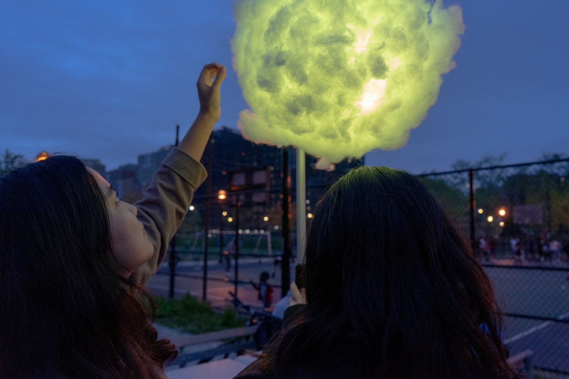
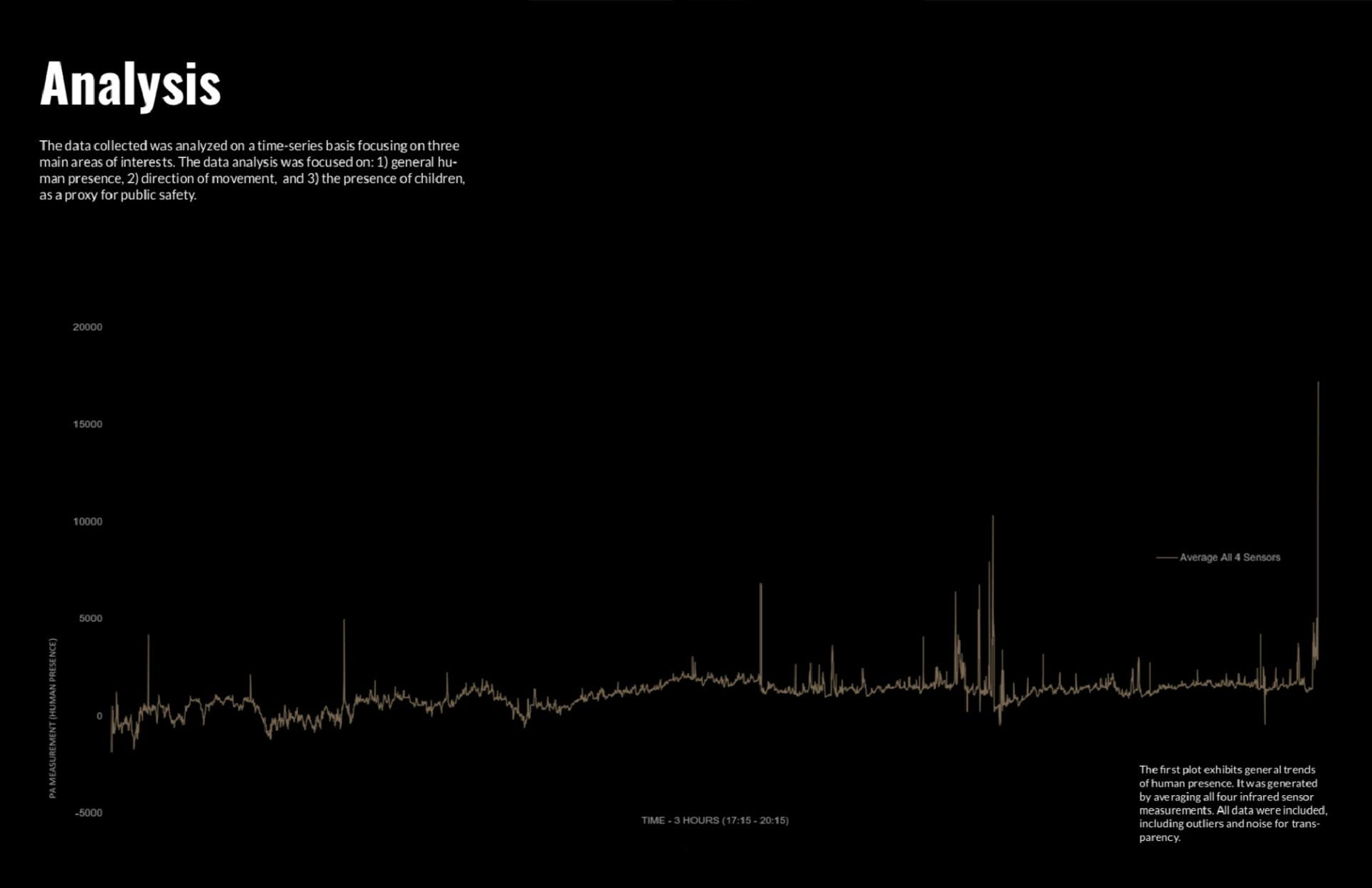
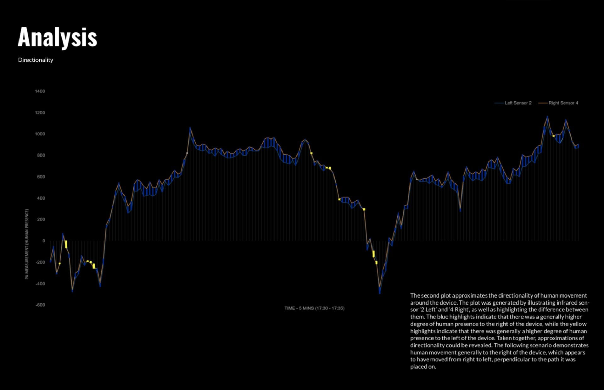
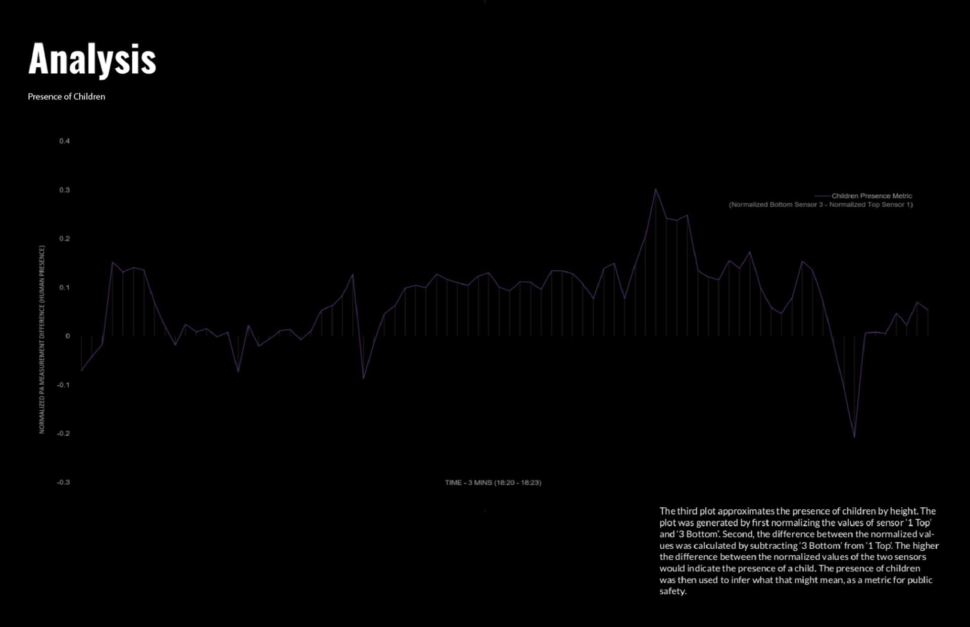
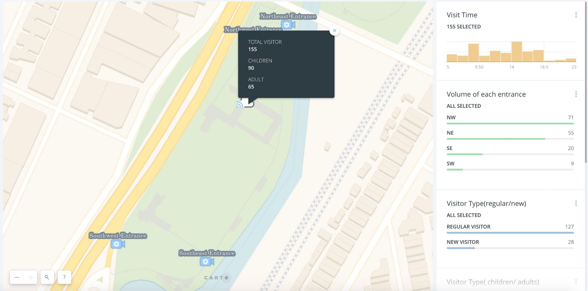
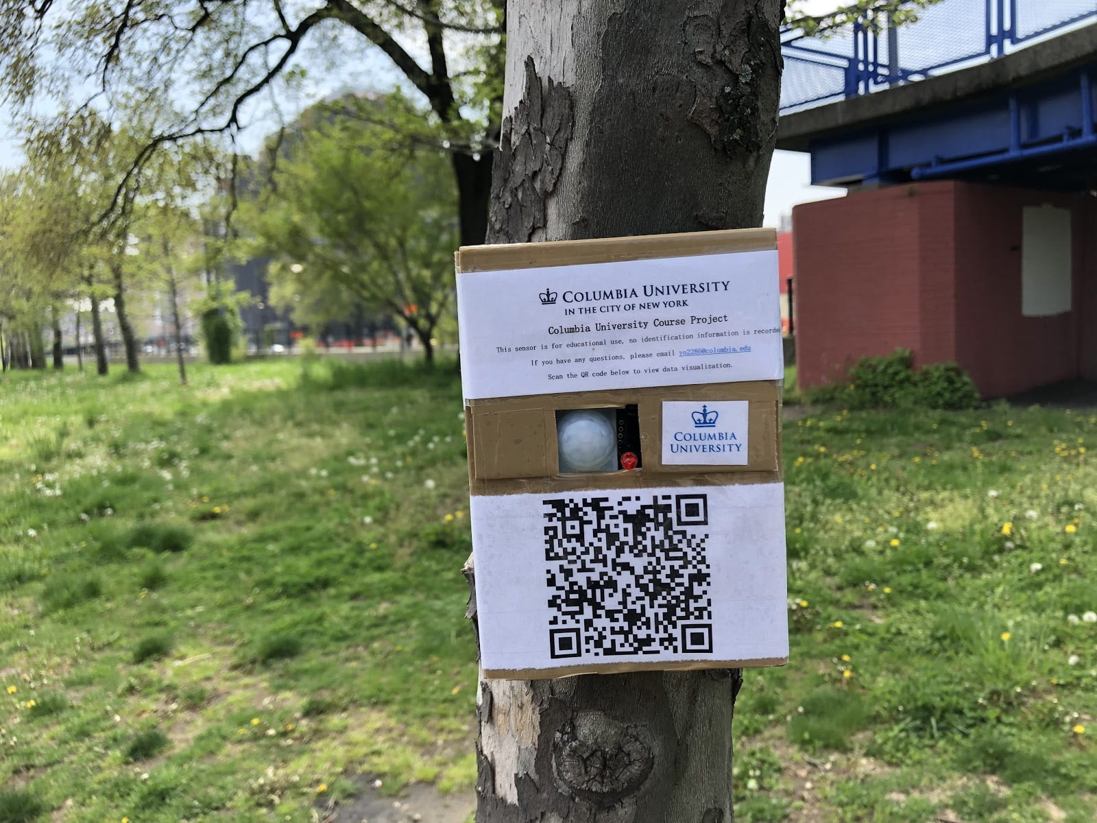
When people come close to the cloud, the light inside will change color, providing feedback to reflect human presence. The presence of people will be recorded by two different sensors located a different heights and stored remotely on the SD board. The two sensors will help us to identify children and adults by their height. The data will then be used to analyze park engagement relative to time and location and visualized on an interactive map in a time-series.

AquaAlert: A Study of Water Quality of the Bronx River

Project Name: AquaAlert: A Study of Water Quality of the Bronx River

Team

Srujana Bhoopanam: sb4010@columbia.edu

Shelby Smith: sts2150@columbia.edu

Project Description

Our project uses sensors to measure the pH values, turbidity level, and ambient temperature of the Bronx River that runs along Starlight Park. We plan to collect data from different testing locations. Our aim is to establish an understanding of the current health of the Bronx River in order to see how these values vary from optimal water quality levels in order to be leveraged as a teaching tool.

In order to do this, we will fabricate a device in the shape of a grouping of lily pads that we will affix the sensors to. Additionally, each lily pad will have a different colored LED light attached to it. As the sensors read the water, the different LED lights will be triggered to display the corresponding quality such that it reflects the condition of the water in real time through the different lights.

Data

pH values, turbidity values, ambient temperature along with GPS location is collected. This is done to see how these values vary from optimal water quality levels in order to be leveraged as a teaching tool.

Harms to the subjects

No human information is collected. Hence, AquaAlert study is harmless to public.

When Walking Into A Park, Where Do You Sit?

Do you remember where did you sit last time when you walked into a park with all types of benches and chairs? Is there any specific reason why you sit on this bench, not the other ones? This is exactly what we hope to explore! Via our project in the Starlight Park, we would like to use the fancy technologies — sensors — to examine when and where do people sit and find out any pattern or predilection, if exists, of people deciding on the seats to take. Specifically, what types or settings of seats do people perfer and does this vary during the day? This will not only help us learn and understand people’s behavior, but will also facilitate designers and place-makers to create more attractive public spaces for our city in the future with more welcoming and favorable seats.

During our measurement, you are encouraged to enjoy your park and take your seats as usual. Sensors, which will be installed to some of the benches, are going to automatically sense your presence. Notice that only your presence and the length of that will be measured — we guarantee that none individual information nor privacy will be included in our measurement. No need to panic, and enjoy your stay!

Thanks for your understanding. If you have any question or concern about this project, you are invited to contact us directly through the following:

Kevin Kim (kk3296@columbia.edu)

Yuan Gao (yg2603@columbia.edu)

Xinyu Liu (xl2803@columbia.edu)