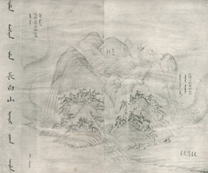
 The mountain lake dripping down the sides
When Ownership Changes
by Sophie Adelman
(body)
[“Latitude 42° N and Longitude 128° E”]
Nobody gave it attention, really. It was just a mountain. In 946 A.D, it formed wrinkles on its sides from viscous lava oozing down. [Volcano eruption sound]
(China-Manchu cosmology)
After it congeale d into a 3,000-meter behemoth, it got names. Paektusan, Golmin Šanggiyan Alin and Changbaishan. Rumor has it that a daughter of heaven once bathed in the crater. She took a bite of an apple delivered by a magpie cow, and , the ancestor of the Qing Dynasty was born shortly after. It was used by the later Qianlong Emperor to claim further boundaries to his empire.[1]
(scar and blemish)
[noise] It never had a pretty history. It’s just a scar, a relic of explosion. It’s scabbed over now but failing to close.
(Korean cosmology)
Manchu legend isn’t the only. Don’t forget, Dangun was born here, too. First king of the Gojoseon Dynasty, born on Paketusan’s jagged peaks to a father of heaven and woman once a bear. The Korean people originated out of Dangun’s realm.[2] A spiritual relationship was grounded in Paektusan’s sturdy crest.
(introduce spinal cord idea)
[“Latitude 42° N and Longitude 128° E”]
It’s the top node, the highly elevated brain. Its body lays out and curves down the peninsula like a spine, its 1400 km length contours the land.[3] If the Baekdu-daegan is its spine, Paektusan is its skull.
(political history)
Paektusan is a danger zone. It’s contested, political. It’s symbolic. It caused Korea and China to fight for years. [battle sounds]. Each “fixed linear boundaries in order to stake out…territories against competitors.[4]” Control shifted from Qing to Choson to Qing and back again to Choson, always slipping through the hands of leaders, soldiers, cartographers, scholars and priests. They paced the base of the mountain to chart, quantify, and claim. The Japanese, too, got their stake in 1910 and stayed there through 1945.
[sound bite]
Then came the divide. The northern rivers flow out of Paektusan laterally, stretching east to west helped fragment China and North Korea, easy. But what about the body?
[duh duh duh…]
Something contiguous was snapped in two.
Half a body without its brain. Two new countries out of thin air. One connected …. the other not.
(nerves and veins, and brain→body)
Nerves are made in rivers and flow outwards from the spine like veins The Baekdu-daegan range is the structure of the peninsula. Korea is a product of Paektusan
(contemporary account)
[play intro clip south Korean national anthem]
frame 119: “Until that day when the East Sea’s waters run dry and Mt. Baekdu is worn away,May God preserve our country for ten thousand years!”
This is the South Korean national anthem, written in 1948, before the divide. It’s not fair to have something taken away from you if you’ve honored it for thousands of years.
And this clip:
[play video of North Korean song]
frame 138: is the North Korean Moranbong Band performing “Let’s go to Mount Paektu.” They’re historicaly the same culture as South Koreans, but they have direct access to Paektusan. As do Manchu and Chinese people. International law deems that South Koreans are forbidden.
Paektusan, 360 degrees
National identity is fluid like geology. Mountains are unstable but perceived as everlasting. They have no empirical direction, no boundaries. Paektusan is an exception. 13 KM wide, thousands more years have passed as have the actors craving its offerings. But no matter when, or in which direction if you descend and travel further away, the crater lake vanishes from sight. Serene from above, a rugged cluster of snowcapped peaks is the remaining piece of the mountain below.
Many thanks to Lan A. Li, Woohyung Tony Lee as well as my classmates for hosting insightful discussions.
References
[1] Kim, 57
[2] http://www.ancient-origins.net/history-famous-people/legendary-founder-korea-dangun-wanggeom-005363
[3] here I think of Dorothy Ko’s chapter on the Erotics of Place
[4] Kim, 50